
Phillips County, Montana
Phillips County, Montana produced 5.5 Bcf of natural gas in 2025. 1,520 producing wells tracked, 12 months to May 2026.
- Third-largest gas-producing county in Montana, 2025.
- 10.8% of the natural gas produced in Montana, 2025.
- Natural gas production fell 5% in 2025 from 2024.
Production
- filling in (est. · missed) . Hatching marks our estimate of the volume still to be filed. That estimate draws on our own production forecast. A check on the forecast behind this estimate measured a miss. It updates as filings arrive
All from what the source published. All held at well grain.
How the volume breaks down
- 100% Reported by the official source by well
Every cubic foot through May 2026 starts from what the official source published for those months. Measured over January 1986 to May 2026.
The bands group wells by when they first produced.
About this chart
The stack shows what is holding today's rate up and how much of it is new drilling. In the reported months the bands draw the filings already in. The months still filling in are marked.
Phillips County, Montana reports no oil production. Its gas is in full below.
Annual table (full history)
| Year | Oil (MMbbl) | Gas produced (Bcf) |
|---|---|---|
| 2025 | 0.0 | 6 |
| 2024 | 0.0 | 6 |
| 2023 | 0.0 | 6 |
| 2022 | 0.0 | 7 |
| 2021 | 0.0 | 7 |
| 2020 | 0.0 | 7 |
| 2019 | 0.0 | 8 |
| 2018 | 0.0 | 8 |
| 2017 | 0.0 | 9 |
| 2016 | 0.0 | 9 |
| 2015 | 0.0 | 10 |
| 2014 | 0.0 | 9 |
| 2013 | 0.0 | 9 |
| 2012 | 0.0 | 10 |
| 2011 | 0.0 | 14 |
| 2010 | 0.0 | 16 |
| 2009 | 0.0 | 17 |
| 2008 | 0.0 | 20 |
| 2007 | 0.0 | 20 |
| 2006 | 0.0 | 18 |
| 2005 | 0.0 | 18 |
| 2004 | 0.0 | 17 |
| 2003 | 0.0 | 16 |
| 2002 | 0.0 | 14 |
| 2001 | 0.0 | 14 |
| 2000 | 0.0 | 13 |
| 1999 | 0.0 | 12 |
| 1998 | 0.0 | 12 |
| 1997 | 0.0 | 11 |
| 1996 | 0.0 | 9 |
| 1995 | 0.0 | 9 |
| 1994 | 0.0 | 9 |
| 1993 | 0.0 | 10 |
| 1992 | 0.0 | 9 |
| 1991 | 0.0 | 8 |
| 1990 | 0.0 | 6 |
| 1989 | 0.0 | 6 |
| 1988 | 0.0 | 6 |
| 1987 | 0.0 | 5 |
| 1986 | 0.0 | 5 |
Source: CommoVision (commovision.com)
Monthly table (last 24 months)
| Month | Oil (Mbbl) | Gas produced (MMcf) |
|---|---|---|
| 2026-05 | 0.0 | 455 |
| 2026-04 | 0.0 | 444 |
| 2026-03 | 0.0 | 452 |
| 2026-02 | 0.0 | 414 |
| 2026-01 | 0.0 | 452 |
| 2025-12 | 0.0 | 457 |
| 2025-11 | 0.0 | 451 |
| 2025-10 | 0.0 | 477 |
| 2025-09 | 0.0 | 462 |
| 2025-08 | 0.0 | 477 |
| 2025-07 | 0.0 | 478 |
| 2025-06 | 0.0 | 464 |
| 2025-05 | 0.0 | 477 |
| 2025-04 | 0.0 | 458 |
| 2025-03 | 0.0 | 459 |
| 2025-02 | 0.0 | 401 |
| 2025-01 | 0.0 | 464 |
| 2024-12 | 0.0 | 465 |
| 2024-11 | 0.0 | 457 |
| 2024-10 | 0.0 | 486 |
| 2024-09 | 0.0 | 484 |
| 2024-08 | 0.0 | 499 |
| 2024-07 | 0.0 | 488 |
| 2024-06 | 0.0 | 483 |
Source: CommoVision (commovision.com)
Source: CommoVision · Phillips County, Montana, data through June 2026.
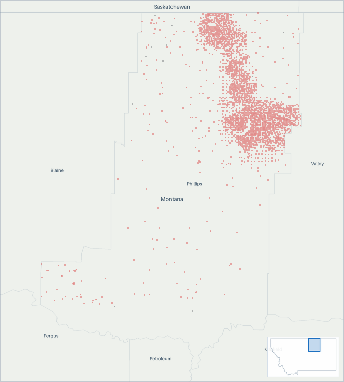
Well map
- Natural gas 2,508
- Undetermined 15
About this map
Undetermined means not enough signal to settle it. Producing wells are the ones that reported oil or gas in the 12 months to May 2026.
Top operators in Phillips County, Montana, 2025
Top operators in Phillips County, Montana, 2025: full table
| Operator | Oil (Mbbl/d, 2025) | Gas produced (MMcf/d, 2025) | Share of output |
|---|---|---|---|
| Ridge Oil & Gas, LLC (March to December) | 0.0 | 15.2 | 84.0% |
| Scout Energy Management (January to February) | 0.0 | 14.5 | 15.4% |
| Saco, Town Of | 0.0 | 0.1 | 0.5% |
| Chelin LLC | 0.0 | 0.0 | 0.1% |
| Diamond Oil & Gas LLC | 0.0 | 0.0 | 0.0% |
Mbbl/d = thousand barrels per day · MMcf/d = million cubic feet per day (units).
Source: CommoVision (commovision.com)
What we cover here
Each row names the grain a region’s production is held at. Where a source publishes at a coarser grain, the page says so.
| Data | Grain | Since | Benchmark |
|---|---|---|---|
| Montana production | well | 1986-01 | ~96–100% of EIA |
Benchmark cells compare our series with the EIA’s published estimates.
About the EIA comparison
The two are produced differently: the EIA estimates from a survey of the largest operators and a model built to anticipate late filings, while the series compared here are rebuilt from the source’s own records as they arrive. Recent months can differ without either being wrong; the methodology page explains both methods.
Coverage rows for Phillips County, Montana are regenerated at every build from the same catalog of sources the data is built from.
What the data shows
- Phillips County, Montana produced 5.5 Bcf of natural gas in 2025.
- Phillips County, Montana gas production peaked in 2007 at 20.0 Bcf; 2025 output of 5.5 Bcf ran at 28% of that peak.
- 1,520 producing wells tracked, 12 months to May 2026.
Get early access
Watch supply move as soon as its sources publish, with forecasts on 1.1+ million producing wells. The portal, an API and MCP access for AI tools open on October 1, 2026.
Data use is subject to our Terms of Service.